The Capital Ring Walk consists of fifteen segments that completely encircle London. The total distance is about 125 km, with each segment consisting of from 7 or 8 km to 15 km or so, easily manageable in two or three hours. The start and finish of the segments coincide with Underground or rail stations. Maps and guides for each segment are available here.

We will organise this as a group, walking every two or three Sundays, weather permitting, with an 11 AM start, and either conclude with a lunch somewhere at the end of the walk, or stop along the way. Perhaps in the warmer months we can plan on a picnic.

We will not walk in the rain, or if there is a strong likelihood of rain or similar foul weather.

Participants are encouraged to make comments and post photographs. If a walk is to be postponed because of bad weather, this will be announced on the blog a few hours before the start.

25 November 2012

Grove Park to Crystal Palace


Today we passed the half-way point on the Capital Ring, completing the eighth segment (out of fifteen). We started early in the year at Hendon Central, roughly at 12 o’clock on the dial, and finished today at Crystal Palace, roughly at 6 o’clock. There were some beautiful parts of the walk, especially through the Beckenham Place Park, but not as much in terms of cultural highlights as on previous walks. There were also some lovely views of the London skyline. This was probably the longest walk we have done, more than 8 miles (or 13 km) in length. The weather was very pleasant, apparently an interlude in what has been a very stormy time here in England.
Entrance to Beckenham Place Park.
From Grove Park, the route proceeds through a park and some residential neighbourhoods until it enters Beckenham Place Park, which appears to be about 1 square km in size. There is a footbridge over the Ravensbourne River and then a lovely part that goes through a wooded area.

But can you have five cats?

Muddy stretch in the Beckenham Place Park.


View of the golf course, with the mansion in the distance.


Front garden in Penge looks like a greenhouse that collapsed.


Telecommunications tower at Crystal Palace.
The path opens up on a golf course, which takes up perhaps one-third of the park. Atop a hill overlooking the gold course in an old mansion. The mansion was linked to the Cator family, who build it in the late 18th and early 19th century. It boasts a number of distinguished visitors, including Samuel Johnson, the botanist Linnaeus and the actor David Garrick.
Dinosaurs in the Crystal Palace Park.
Then the path continues through residential areas until it reaches the town of Penge, which is the gateway to the Crystal Palace. Crystal Palace Park is quite developed, with a huge sports centre, a number of rather odd dinosaur statues, and the BBC tower. The Capital Ring guide claims it to be the tallest structure in London, at 900 ft. But it must be out of date, because the Shard is slightly over 1,000 ft (or 300 m), and claims the distinction of being the tallest building in all of Europe.

24 September 2012

Falconwood to Grove Park


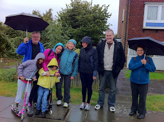
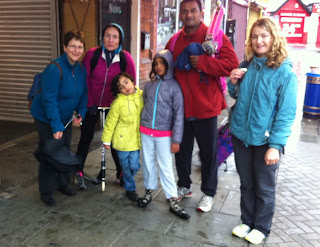
Departing from Falconwood: Nadia, Delfin, Penelope, Radha, Elvira and Joshua.
We almost didn’t do the walk on this first day of autumn. There were serious weather warnings, but we thought we’d take a chance. By the time we got to London Bridge train station, on the way to Falconwood, people had their umbrellas out. Elvira arrived to join us at London Bridge after running a 10k race!
By the time we got to Falconwood Station (where we stopped on the previous walk), it was what we would call in the west of Ireland a ‘soft day’, and so we decided to head out.
This was the biggest group yet, because Joshua Castellino and Elvira Dominguez and their two children, Radha and Delfin, joined us. And a little later, en route, we were met by Eadaoin and Tom, so we were nine.
At full strength, with Eadaoin and Tom.
We walked through Eltham Park and surroundings for about 2 km until we met up with Eadaoin and Tom. One of Eltham’s claims to fame is being the birthplace of Bob Hope!
On one of the trails there was a hollow oak, a bit of a landmark, and Delfin crawled into it. There is an interesting old building called Conduit Head which was the original water supply for nearby Eltham Palace.
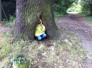
Delfin in the hollow oak.
Indeed, it was Eltham Palace that was the highlight of this walk. We weren't allowed to take photographs, but there are loads on the Palace website.
Built many hundreds of years ago, it was used by Royals for centuries before being trashed during the revolution in the 17th century.  It was used as a farm, and barely saved from total destruction.
Then, in the early century it was obtained by the wealthy Courtauld family, who built a gorgeous art deco mansion on the land. The surviving part of the palace is the magnificent great hall, which adjoins the more modern building.
We planned to stop there only for a bit of lunch, but when we finished our meal it was pouring outside and so we decided to visit the palace. Beautiful and quite eccentric, it is in marvelous condition, having been restored a decade or so ago by the English Heritage.
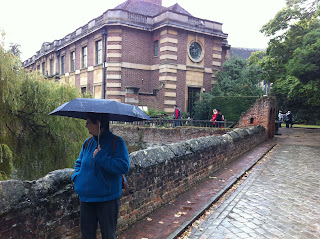
Penelope, on the bridge to the palace.
It felt as if one of the Agatha Christie shows had been filmed here. And sure enough, several of them were in fact set in the palace. Nadia found a tour of the palace on the internet, narrated by David Suchet.
We hesitated about continuing with the walk, because although the rain had subsided somewhat, it was still rather wet. Finally, though, we decided to go ahead, and we didn’t regret it. The route follows by several stables. At one point there is a fabulous view of the London skyline. It was misty and grey, but the beautiful new Shard poked up into the skies.
Grove Park train station, wet and weary.
Joshua got a bit of a thrill as we passed the home of T.G. Grace, a famous cricketer (none of the rest of us had ever heard of him).
The route ends at Grove Park Station. We were all a bit damp, but none the worse for wear, and headed home on the train and the tube. On our next walk we will cross the meridian in south London and proceed to the Crystal Palace. We’ve done seven of the fifteen walks now.
It's great fun, even in the rain!

02 September 2012

Woolwich to Falconwood


After a summer recess, today we resumed our walks around London. We started where we had left off in May, at Woolwich Arsenal station. It is on the south side of the Thames. This is where we crossed the river on our last walk, through the pedestrian tunnel. There was lots going on in Woolwich today because events of the Paralympics are being held nearby.
Woolwich Market, but closed today
We walked along the river in the direction of the centre of London for perhaps a kilometer, up to the flood barrier. Then we headed more or less due south. I’d been warned that this would be pretty dull going, with little of cultural interest and nowhere interesting to stop for a drink or a bite to eat. 
How wrong that advice was! We walked for about 10 km, essentially through continuous parkland. It was gorgeous. There were a few dog walkers but little in the way of crowds. The scenery was varied, with beautiful trees and wildflowers, a few historic old buildings, and some delightful places to stop for coffee and a bite to eat.
Four dogs per walker
Visiting mother goose
From the Thames, the path goes into Maryon Park and then to Maryon Wilson Park. These parks were apparently formed from sandpits, which provided the floors for London kitchens a few centuries ago. There is a children’s zoo which is very charming.
Old Cottage Coffee Shop near Charlton House
The route proceeds to Charlton House, built in 1612 and said to be one of the best examples of Jacobean architecture left in London. We didn’t stop at the House, but in the park where it is located is a lovely café. They were serving salt beef sandwiches, and I was certainly tempted, but satisfied myself with an espresso and a glance at the Sunday papers. There was a cricket match going on in the park that we watched while we had our coffee.
Then the trail crosses the Woolwich Commons, where we saw a field full of wild sweet peas. Then it works its way to Shooters Hill. There is quite a climb. Shooters Hill is mentioned in Dickens’ A Tale of Two Cities, where he speaks of coaches lumbering up the road. It is also referred to in Pickwick Papers. Apparently it was a favorite lair of highwaymen. Pepys refers to gibbets of those who were caught.
Severndroog Castle
From there, the path goes to the Oxleas Woodlands, climbing again to a high point of land where Severndroog Castle is located. The castle is boarded shut, but it still makes an impressive site. It was built as a memorial to Commodore Sir William James, who captured a fortress in India on the Malabar coast in a campaign against piracy. I expect that the Indians have another version of this story.
Nadia and Penelope relaxing near the rose garden
From the castle, the path goes down some rugged steps to a rose garden, part of which is rather neglected and part maintained and very lovely. Then it leads to the Oxleas Meadows where there is a café atop the hill. It has a fabulous view to the south. The food was just good enough – omelets, beans and chips, that sort of thing – but the setting made up for this. I was reminded of the joy of these walks, which involve discovering places in London we would never know otherwise. I expect that few people from outside the immediate neighbourhood know of this place to have brunch on Sunday.
View from the cafe where we had lunch.
Then, it is a short walk through the Shepherdleas Woods and on to Falconwood Railway Station, from where we headed home.
A great day out in weather that was warm, cloudy and fairly humid, but with no rain. We’ll be back walking in a few weeks. Feel free to join us.

28 May 2012

Royal Albert Dock to Woolwich

Nadia and Penelope at Cyprus Place, near the DLR station.
We had a gorgeous, warm summer day for yesterday’s walk around London, in rather abrupt contrast with the weather on the previous walk. This is segment 15 of the Capital Ring, and for those who started at segment 1 (we did not) it is the end. This is the farthest east that the trail gets. The entire walk skirts the river and, at the end, crosses it.
Cyprus DLR station
We met up at Royal Albert Station on the Docklands Light Railway. The train was filled with weird people dressed in strange costumes, not something that one usually finds on public transportation in London on a Sunday morning. They were all going to some comic book costume ball at the ExCel Centre, which is very near London City Airport.
The walk proceeds through Beckton District Park and to the next station on the DLR, which is called ‘Cyprus’. It is named after an estate called Cyprus that was once located there and that was, in turn, named after the Mediterranean island that Britain colonized in 1878. From the station one enters the very nice, modern campus of the University of East London. We were particularly struck by the student residences, which are colourful, cylindrical buildings offering fabulous views of the Thames and of east London. The tall buildings of Canary Wharf are in the distance.
View from the University of East London.
Rowing in the Dock.
This is the Royal Albert Dock, which closed in 1981 after operating for about a century. Ships entered the dock from a lock on the river. It must once have been lined with warehouses and various shipping establishments, but all that remains now is the pretty campus. The dock itself is now used as a place for rowing. The Olympic events will take place here.
Student residences at University of East London.
Poppies.
Rather dodgy pathway near the Lock.
The path continues through a rather dull field and then doubles back to the river. We crossed the lock gates, which are quite tall and dramatic. Then there are several modern apartment buildings and an attractive park, which was filled with people sunbathing and having picnics.
The end of the walk is the Woolwich foot tunnel. The lifts are being repaired, so we had to do the 100 steps down and up again. At Woolwich we wanted to have a drink and something to eat, but there really wasn’t any place decent, so we took the DLR and the Tube to London Bridge and went to a great tapas joint.
On our next walk, in a few weeks, we will start exploring South London.
Crossing the Lock.
Walking through the Woolwich Foot Tunnel.
View from the south bank of the River looking West.
.


07 May 2012

Hackney Wick to London City Airport


Nadia and Penelope Soteriou at the start, 
at Hackney Wick train station.
On a rather chilly May Sunday we walked our fourth segment of the Capital Ring (officially, section 14). We’ve done almost a third of the route now. We finished yesterday afternoon next to the London City Airport, which is a long way from Hendon where we started four Sundays ago.


Our starting point was Hackney Wick, a rather bohème neighbourhood that is in the shadow of the Olympic site. We had finished there on our last walk, but perhaps because we were tired we did not take such a close look. There, obscurely on a wall, was a small plaque indicating where the first plastics were made.
Little statues on the scanal at Hackney Wick.
The guide to the route promised we would have great views of the Olympic installations, but in fact it was a bit of a disappointment. A few days ago, there was a serious security clampdown on the site, and as a result we were rerouted rather far from the stadium and other facilities, which we could only see in the distance. In fact, we got lost, and had to find our way back to the main trail at Stratford High Street.
The Bryant and May Match Factory, with plaque commemorating a famous strike.


Along the way was, as always, the unexpected. We passed by the old match factory of Bryant and May, now refurbished into houses and apartments.
Bow Church.

There is a plaque on the site of the entrance commemorating a famous strike that took place. From there, we passed by the 700-year-old Bow Church.
Had we followed the path, we would have missed these sights.
At Stratford High Street we found the path. It is located above the embankment of the Northern Outfall Sewer which runs for several kilometres. This is now called the Greenway. It is straight and wide and paved, and a good place for cyclists as well as walkers although surprisingly it was not crowded at all.
Taking a short break on the Greenway.
The highlight is the Abbey Mills Pumping Station, a Victorian building that is still used occasionally to pump sewage when there are heavy rains. The Greenway was lined with hawthorn trees which are now in blossom.
Abbey Mills Pumping Station.
The route leads to Plaistow, where we were promised cafés and restaurants. We looked around but it was clear we were no longer in Highgate or Stoke Newington, with their charming bakeries and espresso bars, and in the end we took a pass and kept walking.
At the end of the Greenway the route passes over a highway on a footbridge and then continues through the delightful Beckton District Park.
We were at the end of the route, next to the London City Airport. On our next walk we pick up the route there. We will cross the Thames and move into South London.

08 April 2012

Stoke Newington to Hackney Wick


On an overcast and somewhat damp day, we did our third walk of the Capital Ring, section 13, which goes from Stoke Newington to Hackney Wick. Again, there were four of us: Penelope, Nadia, myself and Michael Kearney who has joined us and who we hope will be back for future walks.
Micheal, Nadia and Penelope at the entrance to Springfield Park.
We began at Stoke Newington train station, walking through a very attractive residential neighbourhood until we reached Springfield Park. It is a very charming park, looking down on the Walthamstow marshes and the River Lea.
Springfield Park is a nature site that has been designated London’s first Regionally Important Geological Site – RIGS – and is on the English Register of Parks and Gardens of Historic Interest. It takes its name from springs that arise in the area. At the bottom of the park is a pedestrian bridge that crosses the River Lea. To the left is the Springfield Marina, full of the narrowboats that navigate the canals.
Catlovers spot a moggy on the roof of a canal boat.
Basically, today’s walk followed the River Lea. The River Lea was the historic boundary between Essex and Middlesex. Most of the time we walked on the old towpath, which is nicely refurbished making for easy walking and cycling.. I think one could live in London for many years and never even know that this beautiful river environment exists. You need to walk or cycle to see it.
No kite flying!
To the left of the path is the Walthamstow Marsh, a huge expanse of land that is part of the larger Hackney Marshes. In the past, it was a summer meadow known as Lammas Land, left to grow and then cut for hay later in the year. Now it hosts a nature reserve.
It was here that the first flight in Britain took place, and there are some small monuments to mark this. In 1909, a bit more than a century ago, A.V. Roe flew his ‘Yellow Terror’ tri-plane for 900 feet across one of the marshes. It was build under the arches of a bridge we walked past.
Springfield Marina.
The Marshes, and site of first flight in England.
Canal boat and pub.
Leabank Square. Check their website.
Colourful new buildings on the riverside.
Passing under a bridge where a weir separates the River Lea from the Lea Navigation Canal, we found a group of people posing for a picture. We guessed that it was a band and, sure enough, they are indeed: We Used to Make Things. Here is their website.
We Used to Make Things.
The Hackney Marshes are also home to an expanse of football pitches, apparently the biggest such collection in the world (and duly listed in the Guinness Book of World Records). There are apparently 80 pitches, and the land is known as the home of English “Sunday Soccer”. But today nobody was playing: perhaps all the matches were called off because of Easter Sunday.
The towpath continues past the Middlesex Filter Beds, which were build in 1852 to remove impurities from the River Lea. They went out of use in 1969.
Protesters camping near the Olympic site.
As we walked along, we began to pick up signs of the Olympics, including a protest camp that has been set up and signs of the efforts of government lawyers to fight off the protesters with injunctions. The Olympic site itself is surrounded by a rather daunting fence, with lots of warning wires and cameras. The only thing missing are machine gun towers and patrolling Alsatians.
Big time security at the Olympic site.
The stadium.
The Hackney Pearl.
We finished at Hackney Wick, and had a drink at the Hackney Pearl, which was the only restaurant we could find in the area. They are gearing up for a huge rush of business when the Olympics take place later this year. We had to wait more than 20 minutes for a bowl of soup. If they want to make money this summer, they’ll have to work on the service.

18 March 2012

Highgate to Stoke Newington

Penelope, Susan and Nadia
We held the second in our series of walks today. The weather wasn't as warm as three weeks ago, but at least it didn't rain. We are still only four (Penelope Soteriou, Nadia Bernaz, Susan Scott-Hunt and myself). A few who promised to join us didn't make it, possibly because of the delayed effects of St. Patrick's Day celebrations last night. Highgate underground station was the starting point. Highgate is famous for its cemetery, where Karl Marx is buried, and for other reasons too. 
From the Highgate tube, the route goes almost immediately to the Parkland Walk. It is actually the right of way of a former railway line, that operated from 1867 to 1970, that went from Finsbury Park to Alexandra Palace and Edgware. Now it is a nature reserve, and there are even some deer although we didn't see any today.
At one point, the Parkland Walk passes through an abandoned station. All that remains are the platforms. There are other signs of railway activity, including various bridges and arches. There has been a lot of decorating by graffiti artists. The route was filled with other walkers, people strolling with their dogs, and many joggers.
Former Crouch End rail station.

Graffiti-covered arches and a spriggan.

Viaduct over the main London to Scotland rail line.
The Parkland Walk continues for perhaps 3 km. At the end, it passes over the main London to Scotland railway line. Then the route enters Finsbury Park. There are some lovely spots in the park, and a café with seats reserved for dog owners!
Café in Finsbury Park with a "Seating area for dog owners".
 The route leaves the Park and then runs along the New River. The path is not paved and it was quite muddy in places. On the right is the Woodberry Down Estate, which is the largest council housing estate in all of Britain. On the left, are industrial sites. Eventually, the path comes to the end of the New River and to two reservoirs. In one of them, there were sailboats and kayaks.
Along the New River.

Swan building a nest on New River.

The Castle was formerly the pumping station.
 After leaving the reservoirs, the route crosses Clissold Park and then reaches Church Street in Stoke Newington. We'd been walking for a couple of hours without a real break, and quickly found a place to have lunch. We stopped in the Fox Reformed, which sits on the site of a former school where Edgar Allan Poe was a student for three years when his father was working in England. The food was delicious: pies made with sweet potato and goat cheese, and beef and stilton cheese. We lingered over wine and desert before deciding to make our way home.
But the high street beckoned. It has some lovely shops, including Homage, where some members of the group indulged in a bit of retail therapy. The Daniel Defoe pub acknowledges one of Stoke Newington's famous residents.
It was a great walk, refreshing and informative. A great way to spend a Sunday afternoon. Please join us on 8 April for the third segment. We start at Stoke Newington, at the rail station, and end at Hackney Wick.
Old churchyard and burial ground in Stoke Newington.

The Fox Reformed.

Formerly a fountain pen repair shop.

Shops in Stoke Newington.